Cookie Consent
By clicking “Accept”, you agree to the storing of cookies on your device to enhance site navigation, analyze site usage, and assist in our marketing efforts. View our Privacy Policy for more information.


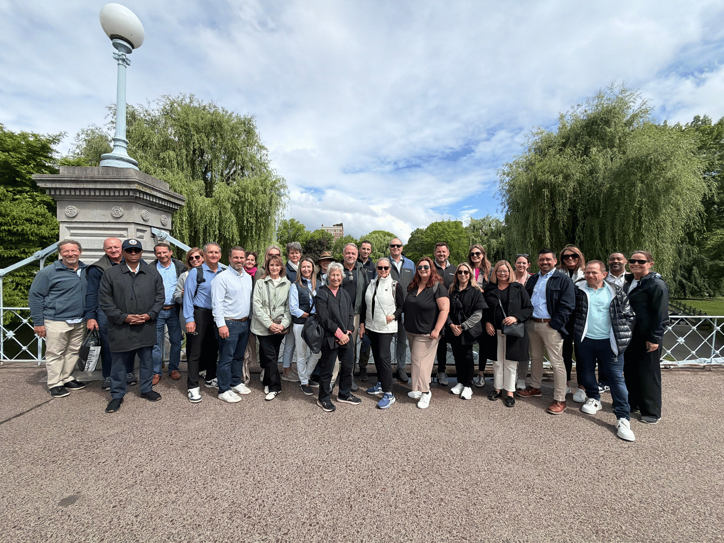
On June 1st, a group of our Sponsor and Supporter level members joined us in Boston for our annual Urban Exploration Trip. This trip is designed to highlight projects in a particular city that demonstrate lessons learned that can be applied to active development projects in St. Pete. In Boston, we visited the Boston Public Gardens, Downtown Crossing, the Rose Kennedy Greenway, and Seaport. Please find some of the highlights and key takeaways from each project below.
Boston Public Gardens
As we continue our initiative to revitalize Williams Park, we think it is important to look at leading examples of management of urban parkland around the country. Dating back to 1839, the Boston Public Garden is the first public botanical garden in the United States. Created by 17 Boston Brahmins — private individuals who envisioned a formal botanical space adjacent to the already-existing Boston Common. The land was officially designated for permanent public use in 1852. The garden's Victorian design — with its meandering paths, cast-iron fencing, ornamental plantings, and central lagoon — was laid out by George Meacham, who won a design competition for the project.
The Public Garden is managed jointly between the Mayor's Office, the Parks Department of the City of Boston, and the non-profit Friends of the Public Garden. The Friends of the Public Garden operate with a 10-person staff and a nearly $4 million budget, augmenting city work and maintenance on the Public Garden, Boston Common, and the Commonwealth Avenue Mall. The Friends oversee approximately 1,700 trees across the three parks they steward, with the beloved lagoon willows being especially vulnerable as the climate grows wetter and stormier.
Key Takeaways for St. Petersburg:
Boston Public Gardens is a great example of the power of private-public partnerships, especially in managing urban parkland. It also highlights the benefits of preserving well-maintained urban parkland in the heart of a city. Numerous studies show that green spaces in urban settings improve public health, moderate the "heat island effect" of dense cities in a warming world, and bring joy to millions.
Learn More:
Friends of the Public Gardens Website
Boston Public Gardens Spotlight
Downtown Crossing
As we launch the St. Pete Downtown Improvement District (St. Pete DID), it's important to look at how other cities conduct their urban management programs. Located at the hub of downtown Boston's retail and transit activity and covering several blocks radiating from a central T stop, Downtown Crossing has always been a popular location for department stores, specialty stores, and eateries. The neighborhood took a nosedive after World War II, becoming a place that was lonely and desolate after dark, despite the daytime shopping bustle. The single most important institutional force in stabilizing and reviving Downtown Crossing has been the Downtown Boston Alliance (DBA), formerly the Downtown Boston Business Improvement District (BID).
The DBA's mission is to significantly improve the experience of all who live, work, visit, go to school, or shop in the 34-block, 100-acre service area by providing supplemental services to keep the district clean, safe, and vibrant while catalyzing an energetic and thriving business climate and serving as the neighborhood's voice and advocate. The DBA deploys several key urban management tools:
Key Takeaways for St. Petersburg:
One of the biggest lessons that Michael Nichols, President of the Downtown Boston Alliance, emphasized that they have learned is that the unique experiences an urban area provides are much more memorable to folks than how clean that area is - as long as a certain level of cleanliness is maintained. As we move forward with St. Pete DID, it's important we remember to prioritize programming in Williams Park as well as customer experience training for our improvement team staff - while still maintaining a desirable level of cleanliness.
Learn More:
Downtown Boston Alliance Website
Rose Kennedy Greenway
As our community thinks about I-175 and ways that the South St. Pete community can be better connected to the Historic Gas Plant District redevelopment, we thought it was important to look at the innovative way Boston addressed a similar issue in their own community.
In the 1950s, Boston — like cities across America — made a fateful choice to route an elevated interstate highway through its downtown. The John F. Fitzgerald Expressway (I-93) sliced through the urban fabric, cutting off the historic North End, Chinatown, and the waterfront from the rest of the city and casting shadows over neighborhoods below. In 1991, after almost a decade of planning, construction began in Boston on the Central Artery/Tunnel Project, more widely known as the "Big Dig" — recognized as one of the largest, most complex, and technologically challenging infrastructure projects in the history of the United States. The project would remove the elevated highway and create a tunnel system below the city. With the elevated highway relocated underground, community and political leaders seized the opportunity to enhance the city by creating The Greenway — a public park that re-connected some of Boston's oldest and most vibrant neighborhoods, and the city itself with the waterfront.
Key Takeaways for St. Petersburg:
The Rose Kennedy Greenway is not only another exemplary model for private-public partnerships, but also demonstrates how successful innovative ideas can be for addressing big community problems, like the division of communities from urban centers. The location of the Greenway next to Seaport, a successful large-scale master planned neighborhood, mirrors I-175 and the Historic Gas Plant District redevelopment in Downtown St. Pete. Walking through both projects highlighted how intertwined the success of each are to each other: without Seaport, the Greenway would not have been as successful, and vice-versa.
Learn More:
The Rose Kennedy Greenway Website
Rose Kennedy Greenway Spotlight
Seaport
As our community prepares for the Historic Gas Plant District redevelopment, it's important we look to other large-scale master planned neighborhoods to see how they were successful and learn from the weaknesses. first began to take shape in the 1850s as an industrial zone built on landfill, largely shaped by train tracks, freight terminals, and industrial fishing piers. In the early 1900s, the area came alive with ships delivering goods to nearby factories, making it one of Boston's busiest commercial ports. But the mid-1900s brought steep decline — factories shut down or relocated, and the area became known for empty lots and abandoned buildings.
Beginning in the 1990s, two unprecedented public investments — the Big Dig and the Boston Harbor cleanup — sparked new interest in the largely vacant waterfront property just a short distance from the Financial District. The $14.6 billion Big Dig buried the formerly elevated I-93 interstate, which had previously cut off the waterfront from the rest of the city, and extended I-90 eastward through the Seaport all the way to Logan Airport. In January 2010, Mayor Thomas Menino launched an initiative dubbed the "Boston Waterfront Innovation District" — a plan to take approximately 1,000 acres of underdeveloped South Boston waterfront and create a work/live/play environment designed to attract technology and innovation companies.
WS Development, the lead developer, has delivered something genuinely impressive by the metrics of private real estate development — a massive, architecturally ambitious, increasingly sustainable mixed-use district built from scratch on what was once a wasteland of parking lots. Their commitment to public realm, Harbor Way, and net-zero sustainability sets real benchmarks for urban development. But the Seaport also represents the limits of what private development — even well-intentioned, thoughtfully managed private development — can achieve without stronger public policy mandates for affordability, equity, and integration. The neighborhood WS built is extraordinary for those who can afford it. The harder question Boston continues to grapple with is who it was actually built for.
Key Takeaways:
The location of Seaport next to the Greenway, a linear park located above the buried interstate highway through its downtown, mirrors the Historic Gas Plant District redevelopment and I-175 in Downtown St. Pete. Walking through both projects highlighted how intertwined the success of each are to each other: without Seaport, the Greenway would not have been as successful, and vice-versa.
Seaport also highlights the importance of prioritizing affordability, equity, and integration in master planned neighborhoods, to ensure that it is built for all the residents in the intended community.
Learn More:
If you are interested in participating in future urban exploration trips, please reach out to Nicole Roberts at nicole@stpetpartnership.org to find out more about becoming a Sponsor or Supporter level member.


Follow Us

